Reposted from the Northeastern Jewish Studies Blog
Student Projects in Northeastern’s Jewish Studies Use Digital Tools to Explore and Exhibit Boston’s Complex Jewish History
Last spring I reported on the NUJS Blog about a new class in the works that would use Boston’s Jewish history as a subject for learning how to use digital history tools, and digital history as a method for students to study Boston’s Jewish history.
In this class, held during the fall semester 2020, we had workshops with pros from the Northeastern Library’s Digital Scholarship Group and its Archives and Special Collections, with digital humanities specialists in the NULab for Digital Humanities and Computational Social Science, with a professional cartographer from Beehive Mapping, with an archivist and educator at the Wyner Family Jewish Heritage Center at New England Historic Genealogical Society, and with colleagues in the History Department who specialize in spatial history and 360 degree reconstructions. We also went into the streets and explored by foot in East Boston, Beacon Hill, the North End, South End, Roxbury, and Dorchester.
At least by measure of the sophistication of the students’ work (and I hope too by how much they learned), the class was a success. In December we launched the site DHJews of Boston which exhibited the two collaborative projects created by this intimate seminar. I had the pleasure in January of presenting about the class and showing off the student projects at a (virtual) conference organized by the University of Luxembourg called Jewish Studies in the Digital Age. And I was recently thrilled to add a new project completed in the spring semester by a student in my class Jews in the Modern World (JWSS/HIST 1294). I’ll continue to work with students who want to create digital history projects that can be exhibited on the DH Jews of Boston site. In particular I’d like to add more exhibits featuring 360 degree photography of Jewish space. Below is a short overview of the three student projects currently on the site–please check them out for yourself!
2020-21 DH Jews of Boston Student Projects
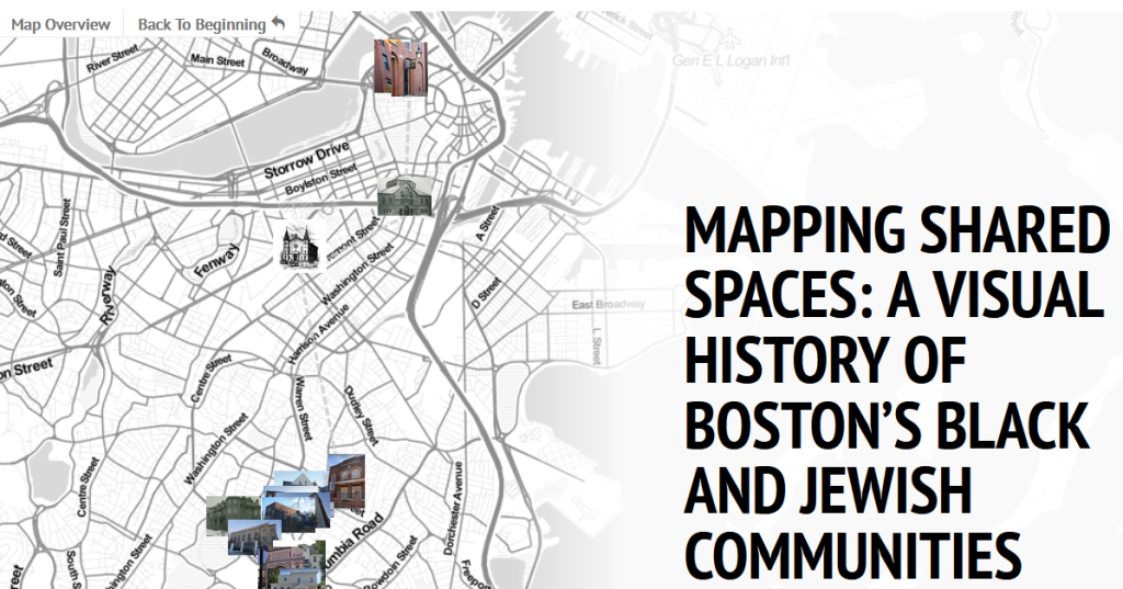
Harrison Beiser, Kayla Lavelle, and Shira Weiss worked together to create a digital story-map called Mapping Shared Spaces: A Visual History of Boston’s Black and Jewish Communities. This interactive story-map allows readers to explore neighborhoods where Boston’s Jews and blacks lived together during different periods of Boston’s Jewish history. The map’s narrative begins with black sacred spaces that became synagogues in today’s Beacon Hill (formerly West End), and moves on to synagogues and Jewish communal and educational institutions that became predominantly black churches and communal institutions in the South End, Roxbury, and Dorchester. One institution, Freedom House, served as a center of both black and Jewish activism and integration and is still an important community institution in Dorchester. In building the map, students made use of their own photographs (still and 360), Northeastern’s Archives and Special Collections, and google’s 360 mapping, in addition of course to extensive reading and research. The result is a beautiful tour of these important shared spaces.
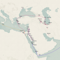
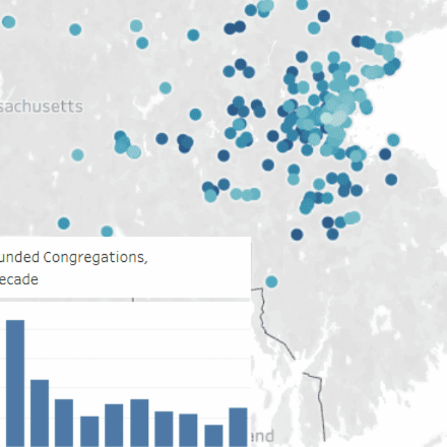
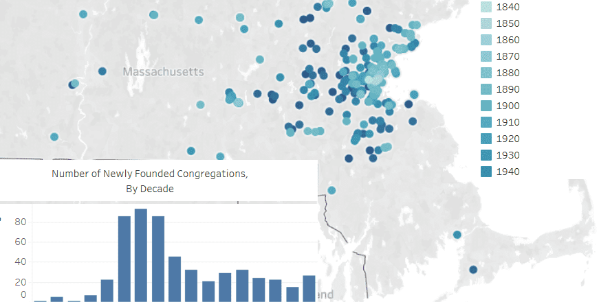
Jasper Trouerbach mapped the migration of Boston’s Jewish community in a different way, using historical data about the founding and closing of synagogues, using the software program Tableau. In Shifting Neighborhoods: How Boston’s Jewish Communities Moved, 1850-2000, Jasper created a series of maps and explanations plotting the Jewish community’s decade-by-decade migration within and out of Boston. From Jasper’s visualizations, a clear picture emerges of the Jewish community’s steady suburbanization. One can see in these maps and charts a steady move of Jews outward, from the North End to the West End, into newer suburbs eastward into East Boston and Chelsea, westward into Brookline, and most significantly the steady founding of new synagogues progressively southward in the city, first in the South End, then Roxbury, then Dorchester, then Mattapan (which was at the time part of Dorchester). As Jasper points out, Jews began leaving the city, including fairly newly established neighborhoods, in significant numbers beginning in the 1930s, well before government engineered red-lining in the late 1960s would ultimately have a devastating effect on the remaining Jewish community in the southern part of the city.

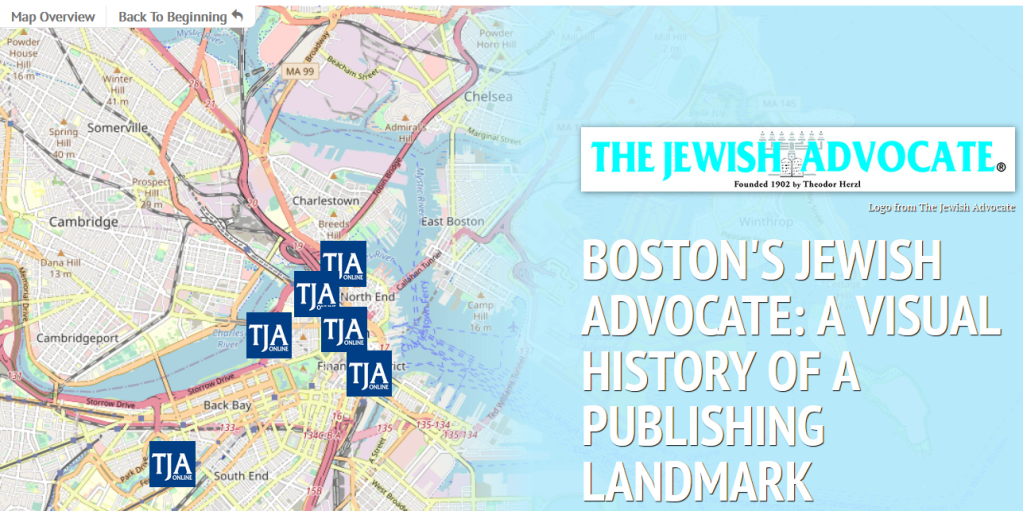
Nate Gillin created a digital story-map called Boston’s Jewish Advocate: A Visual History of a Publishing Landmark. Nate constructed an interactive map that narrates the history of Boston’s Jewish Advocate newspaper: from its origins as a source of revenue for the city’s Jewish hospital, to its association with the Young Men’s Hebrew Association, to its role in drawing out Louis Brandeis’s Zionism, and ultimately to its fading significance. Publishing for well over a century, the Jewish Advocate was a key element of both Boston Jewish and American Zionist history, and Nate used his own photos, as well as archival, digital, and print sources to create this compelling exhibit.
The creativity and diligence of these phenomenal Northeastern students shines in all of these projects. I hope the public learns and enjoys from them as much as I did. As an ongoing project, I’m very much looking forward to seeing how future student’s expand and contribute to our DH Jews of Boston site.