By Molly Nebiolo, PhD Candidate, History
3D modeling as a digital humanities tool has existed for a while, with very detailed projects like the Pudding Lane Production of Tudor-Era London, 3D Saqqara, and Virtual Angkor. But how can it be used on a smaller scale, and are the tools too difficult for individual people to learn and use? As someone who has recently taken up the task of learning and incorporating 3D modeling into a small DH exhibition, I can confirm that it is both attainable to learn and exciting to use.
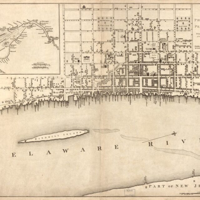
As a part of my dissertation, I plan to develop a digital exhibit to include with my project. The aim for this project is to outline the history of colonial urban space in early America, visualizing these spaces beyond the maps that remain, which will help me (and hopefully others) to better conceptualize early colonial spatial history. One portion of this public-facing project will be to digitally recreate a portion of colonial Philadelphia based on the 1776 map of the city created by Andrew Dury. In this post, I’ll explain the processes I have completed thus far with the exhibit and share some things to note if the reader is considering these tools themselves.

3D modeling takes time and requires various programs before a polished visualization is produced. In the case of my project, I use SketchUp Pro and Unity. SketchUp is the space in which the objects of the visualization are created. For me, this meant recreating various eighteenth-century buildings that would have existed in colonial Philadelphia. The research for this took time. For every structure I built, the dimensions for everything were needed. Soon, I understood the extent to which I had to find the measurements of smaller, more trivial parts: the size of windows, their shutters, the molding around doors and windows, the estimated height of each floor, and how much the roof projects off from the rest of the building. I needed to become a very amateur architect. The time put into finding each detail was something I had not accounted for, but was a fun process, nonetheless. Luckily, there are many architectural historians that note these details in their journal articles and on the websites of National Historic Landmarks like Elfreth’s Alley. This process of piecing notes together made it possible for me to build a couple of the rowhouses that still exist in certain parts of the city.
Sketchup itself is easy to use. YouTube videos help, but as long as you have the dimensions of your object, they can be inputed. The challenge comes in the amount of objects needed for the 3D model, and deciding how much detail to put into each object. For me, the purpose of my project is to provide a visualization of the spatial construction of what Philadelphia felt like for someone walking down the street. As can be seen in Figure 1, I decided against many ornate detailing, but kept the integrity of a basic two-story rowhouse.

For this project, I decided against making each individual building for the segment of town I will recreate. Instead, I decided to build three structures which I will diversify with various textures and colors to mimic different buildings. This latter stage is done in Unity, which is why the Sketchup Images (see Figures 1 and 2) are unadorned with color or texture.
The objects, in this case houses, are saved and exported so they can be imported and used in Unity, the platform where the 3D modeling of Philadelphia will unfold. Unity is quite complex, but it allows for many possibilities, from making video games to rebuilding historical spaces. Once objects are imported into Unity, their location in space, their textures, and their shadows can be manipulated to produce the best experience for the viewer. The basics of Unity can be learned through their introductory activity, Roll-a-Ball, among other “courses” and forums that provide helpful orientations for Unity. Some processes in Unity require the usage of C# (C Sharp) code, but Code Academy has a great tutorial for learning the basics, and there are plenty of resources out there on using Unity and C#.
Overall, I have found the process of learning how to 3D model surprisingly easy and fun to do. While the process has many things to learn and a couple of programs to use, the project has liberated my notions that 3D modeling is unattainable for individuals. I hope my project can be an example people can turn to if they want to use 3D modeling for their own ideas. Of course, one of the strengths of DH is the ability to collaborate, and this project is not any different. I would not have been able to complete this without a NULab seedling grant to purchase the programs nor obtain the space and resources for feedback I have gotten with my fellowship at the American Philosophical Society. Additionally, the help of Jessica Linker as both a springboard for project outlines and a guru with Unity, has also been advantageous for the quality of the project I want to produce.
3D Modeling is just starting to be recognized and used by more digital historians, like Serena Zabin’s Witness to the Revolution video game. It is an exciting way to interact with and visualize data. Most importantly, it is becoming more user-friendly as time goes on, and I hope more DHers begin using it for their own data projects.
(Due to the restrictions related to the coronavirus pandemic, my DH fellowship at the American Philosophical Society was cut short. I plan on completing the project sometime this spring or summer.)