Principal Investigator: Ayah Aboelela
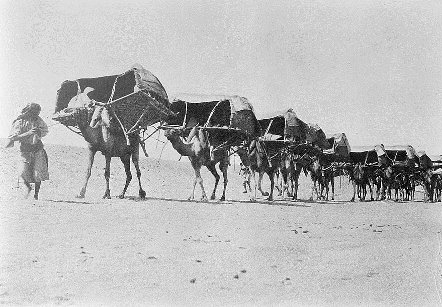
Every year, tens of thousands of Egyptian Muslims travel to Mecca to perform the Hajj. Usually, they travel by airplanes, buses, and cars. But in the late nineteenth and early twentieth centuries, under Ottoman and British rule, they relied on steamships, railways, and camels. At this time, steamships and railways were relatively new options that would transform the pilgrimage itineraries of Muslims from around the world. This was when the official Egyptian Hajj caravan began incorporating steamships and railways as transportation options–no longer solely dependent on travel by foot or riding animals. Moreover, Egyptian pilgrims were increasingly designing their own pilgrimage itineraries, rather than depending on the official state caravan.
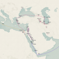
In this digital history project, I map the journeys of Egyptian Muslims traveling to Medina and Mecca (which are in the Hijaz, or western Arabia) in the late Ottoman era, from 1877 to 1916. Thanks to the Arab Nahda (renaissance) and the boom of the printing press in Egypt, this period witnessed several published works by Egyptian pilgrims detailing their journeys, often including maps, charts, and tables listing stops like train stations, sea ports, oases, villages, and even coffeehouses. Scouring these sources, I produced two online, public components: one, a database of the locations in Egyptian pilgrims’ itineraries from this period, which informs my second component: a digital map designed in ArcGIS displaying these locations.
By mapping individual Egyptian Muslims’ pilgrimage routes, we can better understand the ways they perceived places and borders at a time when contemporary nation-state borders did not exist in the region. Although we might see travel in the contemporary world as far more convenient, it is also limiting because of prevalent, often nationalist, ideologies. As will be explored more deeply below, before the rise of Zionist settler colonialism, many Muslim pilgrims once visited Jerusalem as part of their Hajj journeys. While this is no longer so easily undertaken today, this project’s exploration of historical Hajj itineraries shows that today’s Hajj itineraries were not inevitable.

Historical Context
This project contributes to historical discourse on Muslims in the age of print and steam. My period of focus, 1877 to 1916, marks the turbulent last four decades of the Ottoman Empire. After losing much of its territory in Eastern Europe and North Africa, the Ottoman Empire turned its attention to centralizing power over its remaining Arab provinces.[1] Although Egypt was nominally under Ottoman rule until World War I, by 1882 it was placed under de facto British control and occupation. The Ottoman state, hoping to consolidate its grasp over its remaining Arab provinces, particularly in Greater Syria and the Hijaz, implemented several infrastructural projects, such as railway and telegraph lines.[2] These included the various regional railway lines inaugurated in Palestine, Syria, Lebanon, and Transjordan in the late nineteenth century, followed by the Hijaz Railway that connected Damascus to Medina starting in 1908. This technology would be utilized by several pilgrims–many of whom would write about their experiences and publish them using Egyptian presses. A sample of these writings forms the source base of this project.
This project visualizes the various routes taken between Egypt and the Hijaz between the 1870s to the 1910s, highlighting differences between the new steamship and railway routes in comparison to overland (often walking or riding) journeys. Although most of my sources detail routes taken by the official Egyptian Hajj Caravan, I take particular interest in the non-conventional routes that reveal the ways new transportation technology may have transformed traditional routes and shaped spiritual experiences and interpretations of borders.

For example, before the inauguration of the Hijaz Railway from Damascus to Medina in 1908, Egyptian pilgrims typically traveled by rail to Suez, then embarked on a steamship to a Hijazi port (usually Jeddah, Yanbu, or Rabigh). From there, they traveled by foot or rode animals to Mecca. After 1908, many pilgrims took advantage of the new Hijaz Railway to plan their own trajectories, often including Jerusalem in their itineraries. Muhammad Hasan Ghali, one of the pilgrims whose writings I use in this project, particularly encouraged his Egyptian Muslim readers to utilize the new Mediterranean steamship routes and Levantine railway network to reach the Hijaz so that they could visit Jerusalem. While Muslim pilgrims have visited Jerusalem and other holy sites in Palestine as part of their journeys to Medina and Mecca for centuries, the increased transportation options made it easier for Egyptian pilgrims in particular to do so.

I argue that travel to Jerusalem as part of the Hajj journey is a significant phenomenon for historical study because of its rarity today. Contemporary Muslims, although seemingly given much more flexibility in transportation, no longer regularly visit Jerusalem–neither as part of their pilgrimage journeys to Medina and Mecca nor even on its own. The settler-colonial Zionist project has isolated Jerusalem from its historically central role in Muslim pilgrimage routes. But by examining pilgrim accounts from the time before the Balfour Declaration and the British Mandate over Palestine, we can see that this isolation is a modern exception that was never historically inevitable.


Sources
So far, I have scoured seven Arabic travelogues published between 1877 and 1916 by four Egyptian travelers to the Hijaz. The travelers and their writings are as follows:
- Muhammad Sadiq Bey: a geographer, engineer, and photographer for the Ottoman Egyptian army who was the first to photograph the holy cities of Medina and Mecca as well as other parts of the Hijaz. He visited the Hijaz several times throughout his life, often taking on official positions in the Egyptian Hajj Caravan. His occupation made him particularly observant of the landscapes he traveled through, which he thoroughly detailed in at least four books. His book titles are transliterated and translated as follows, detailing his trips in 1861, 1880, 1881, and 1884 respectively:
- Nabdha fī istikshāf ṭarīq al-arḍ al-ḥijāziyyah min al-Wajh wa Yanbuʿ ilā al-Madīnah al-Nabawiyyah wa bayān kharīṭatiha al-ʿaskariyyah (A Brief Account of the Exploration of the Hijazi Landscape from al-Wajh and Yanbu to the City of the Prophet [Medina] and a Presentation of its Military Map)[3]
- Mashʿal al-maḥmal (The Torch of the Maḥmal [ceremonial pilgrimage palanquin])[4]
- Dalīl al-Ḥajj lil-wārid ila Makkah wal-Madīnah min kul fajj (Hajj Guide for those Incoming to Mecca and Medina from Distant Paths)[5]
- Kawkab al-ḥajj fī safar al-maḥmal barran (The Shining Light for the Hajj in the Overland Journey of the Maḥmal)[6]
- Muhammad Labib al-Batanuni Bey: somewhat of a court chronicler, having accompanied the khediwe (the Egyptian ruler) of Egypt, Abbas Hilmi Pasha II, on his various trips, including to Europe. In Al-riḥlah al-ḥijāziyyah li-wali al-niʿam al-ḥājj ʿabbās ḥilmi bāshā al-thāni khidīwi miṣr (The Hijazi Trip of the Gracious Patron the Pilgrim Abbas Hilmi Pasha the Second, Khedive of Egypt), Batanuni describes the journey of the khediwe and his royal mother and daughters on his 1909 Hajj trip, outlining their itineraries.[7]
- Shaykh Muhammad Hasan Ghali: unlike the other travelers here, we know very little about Ghali beyond the fact that he was a graduate of Dar al-Ulum, a teachers’ training school in Egypt, and was the headmaster of a school in Tanta. Moreover, instead of traveling in an official caravan, Ghali carved a route of his own in 1912. His book, Dalīl al-wuṣūl ilā ziyārat al-rasūl (A Guide to Arriving to a Visit of the Messenger [Prophet Muhammad ﷺ]), was published at the start of World War I in 1914. The book’s title page promised to donate a portion of the proceedings to the Ottoman navy–which is notable because the Ottomans were opposed to the British, who were the effective rulers of Egypt at the time.[8]
- Rashid Rida: an infamous Muslim intellectual and Islamic reformer. Born in Lebanon, he was educated in Egypt and from there published his own periodical, al-Manār (The Lighthouse) which lasted for decades and gained subscribers from as far away as Southeast Asia and South America. Between 1916 and 1918, he published a series of articles titled “Riḥlat al-Ḥijāz” (Journey to the Hijaz) in his periodical about his 1916 Hajj. This journey is especially unique as it is the first Hajj in centuries that was outside of Ottoman control: the Arab Revolt had just launched with the support of the British, and its leader, Sharif Husayn, gained control of the Hijaz.[9]
Output One: Database
Examining the routes described in my selected sources, I created a database using AirTable with the locations of major and minor stops, listing the dates they were in use, transportation methods, primary sources, and facilities (such as quarantines, hospitals, train stations, oases, wells, coffeehouses, lodges, and others). Currently, these total over 200 locations and can be viewed at this link. These locations are largely train stations, sea ports, or way stations–places that travelers mentioned passing by or stopping at during their on-foot or animal travel routes.
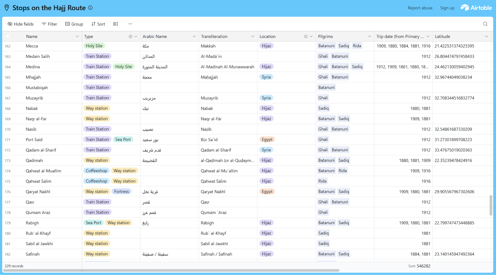
Some of these locations have easily identifiable coordinates. For example, the Ottoman train stations in Damascus and Medina are still standing, and I acquired their coordinates from Google Maps. However, many place names listed in the memoirs are not recorded on Google Maps. Often, this may simply be because the places have been abandoned: several desert way stations or landmarks have not been in use for decades due to new transportation methods (cars, buses, and airplanes), so their names have changed or have not been officially recorded. In these cases, I used different methods to find them:
- Individual users sometimes uploaded data to Google Maps, marking locations with the same names used by the late Ottoman Egyptian pilgrims. If these user-uploaded names were in the same approximate location mentioned by the pilgrims, I recorded those coordinates in the table.
- Andrew Petersen’s book on the archaeological sites along the Syrian Hajj route has recorded the coordinates corresponding to various stations along the Hijaz Railway.[10]
- Public history sites such as AlHejaz.org and Nabatea.net are non-official community efforts to preserve cultural heritage and contain useful information on several railway stations in the Ottoman Arab provinces.[11]
In other cases, especially in historic Palestine, locations mentioned in older memoirs have either had their names changed or have been destroyed by Israel since 1948. For example, Ghali listed the “Balad al-Shaykh” station as part of the Haifa-Damascus railway line, but I was unable to find this station or village name on Google Maps. It was instead preserved by the public and digital history website, The Interactive Encyclopedia of the Palestine Question (PalQuest), which aims to document historical Palestinian villages that have been ethnically cleansed or depopulated by Israel.[12] According to its page about Balad al-Shaykh, the village that once had an important railway connection was depopulated during the 1948 Nakba, renamed Tell Chanan, and repopulated with Zionist (largely European) settlers. If not for the work of projects like PalQuest and Palestine Remembered recording these village names, the name “Balad al-Shaykh” might have been lost forever.[13]
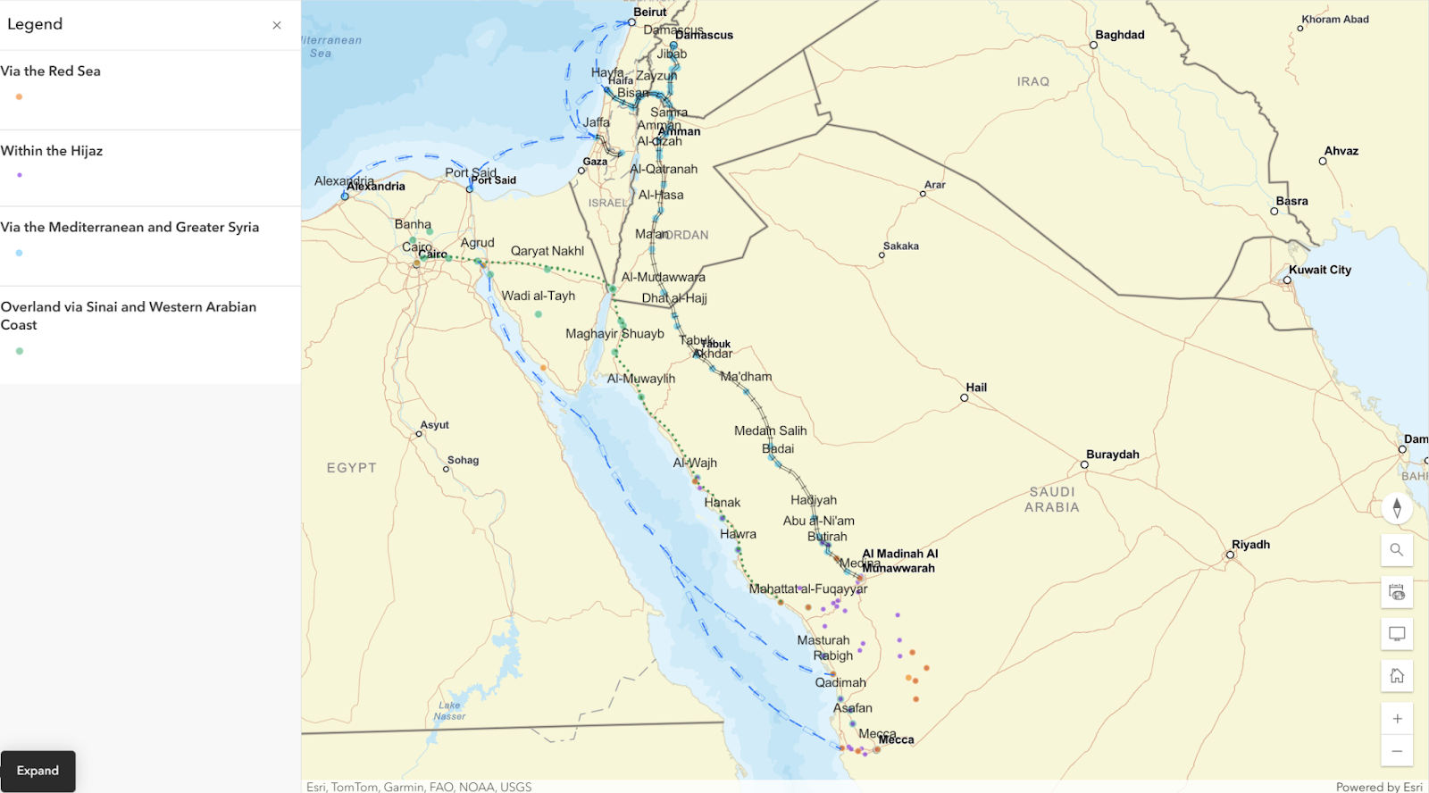
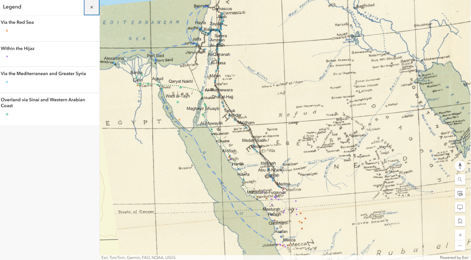
Output Two: Map
The database informs my second, more visual component: a map designed in ArcGIS showing different itineraries from Egypt to the Hijaz. Users can access the map directly and interact with it at this link. Four layers of the map correspond to the four routes used by Egyptian pilgrims at the time:
- Overland, relying primarily on riding animals and/or walking. This appears to have still been the most common and most affordable route, although it took the longest amount of time: approximately 40 days one way.
- The Red Sea route, in which Egyptians would usually use railways or other means of transportation within Egypt to reach Suez, then board a steamship to a Hijazi port, then ride animals to reach Medina and/or Mecca.
- The Mediterranean route combined with the Syrian Hajj route, in which Egyptian pilgrims would use steamships from the northern Egyptian coast to reach Palestine, travel overland to a station along the Hijaz Railway (that started in Damascus), then use the Hijaz Railway to get to Medina. As the Hijaz Railway was only inaugurated in 1908 and was destroyed in WWI by the British and Arab anti-Ottoman rebels, this is the least represented group in my source base.
- The fourth layer represents various locations within the Hijaz, between the inland holy cities of Medina and Mecca and port cities like Jeddah, Yanbu, al-Wajh, and Rabigh. As the Hijaz Railway from Damascus never continued south of Medina to Mecca as planned, travel between these places at the time was largely on foot or via riding animals.
Once the coordinates were uploaded to the map, I sketched lines indicating the routes taken–for all except the paths between Medina and Mecca. Pilgrims noted at least four routes between these cities at the time, but because a highway for motor vehicles has long replaced on-foot travel, several place names recorded in historic pilgrim accounts are no longer traceable without in-person scavenging. Because of the missing locations, hand-sketched routes would likely be highly inaccurate, so I decided not to do so for these routes.
Another challenge I faced when designing this map was choosing which base map to use. Most of the base maps offered by ArcGIS reflect contemporary nation-state borders, which are completely different from the period before WWI. Instead, I used a map drawn in 1916, without any national borders, and attached it as a media layer to a standard ArcGIS basemap.[14]
Conclusions
This project records and visualizes the various routes taken by Egyptian pilgrims to reach Medina, Mecca, and Jerusalem. It shows that this was a time of transformation in transportation methods, as pilgrims used steamships, railways, and other means to reach the holy cities. This work will therefore lead to future research about Hajj experiences at this time. By examining other itineraries–for example, by pilgrims traveling from places other than Egypt, or trips taken before or after the bounds of this study–we will better understand the transformations that occurred at the time. I argue that understanding these different routes allows us to understand the ways individuals perceived regions, localities, and geographies, often through a spiritual perspective, before the rise of nation-state borders in this region. I also argue that these routes show us that current Hajj itineraries were never inevitable. While Muslims today are no longer able to normally visit Jerusalem as part of their pilgrimage itineraries, the accounts examined here show that this was once not so extraordinary.
Acknowledgments
As a Research Associate for the NULab/Digital Integration Teaching Initiative, I developed this project alongside my work for the Wapping Dispute, a NULab project directed by Sam Kemp and Amil Monahan. Consulting with Sam Kemp, I used StoryMap to develop a poetic landscape, titled “Fortress Wapping,” which aimed to imagine and reconstruct the experiences of picketers in the Wapping Dispute in London in the 1980s. Through my work for the Wapping Dispute project, I explored ArcGIS and its various mapping tools, which I then applied to this project. I thank Sam Kemp for his mentorship and support throughout this project. I thank Bahare Sanaie-Movahed for her expert GIS advice, as well as Sarah Connell, Nick Beauchamp, Sean Rogers, and the NULab/DITI team for their support and feedback for this article. Thanks also to my advisor, Ilham Khuri-Makdisi, who directed me to important primary sources and provided invaluable encouragement. All mistakes and views here are my own.
References
[1] Mostafa Minawi, The Ottoman Scramble for Africa: Empire and Diplomacy in the Sahara and the Hijaz (Stanford, California: Stanford University Press, 2016).
[2] Johann Büssow, Hamidian Palestine: Politics and Society in the District of Jerusalem 1872-1908, The Ottoman Empire and Its Heritage 46 (Leiden Boston: Brill, 2011); Murat Özyüksel, The Hejaz Railway and the Ottoman Empire: Modernity, Industrialisation and Ottoman Decline, Library of Ottoman Studies 39 (London: I.B. Tauris, 2014).
[3] Muḥammad Ṣādiq Bāshā, “Nabdha fī istikshāf ṭarīq al-arḍ al-ḥijāziyyah min al-Wajh a Yanbuʿ ilā al-Madīnah al-Nabawiyyah a bayān kharīṭatiha al-ʿaskariyyah (1294 AH – 1877 CE),” in Al-Riḥalāt Al-Ḥijāziyyah, ed. Muḥammad Himām Fikrī (Badr lin-Nashr wat-Tawzīʿ, 1999).
[4] Muḥammad Ṣādiq Bāshā (Muhammad Sadiq Pasha), “Mashʿal al-maḥmal (1894 CE),” in Al-Riḥalāt Al-Ḥijāziyyah, ed. Muḥammad Himām Fikrī (Badr lin-Nashr wat-Tawzīʿ, 1999).
[5] Muḥammad Ṣādiq Bāshā (Muhammad Sadiq Pasha), “Dalīl al-Ḥajj lil-wārid ila Makkah wal-Madīnah min kul fajj (1896),” in Al-Riḥalāt Al-Ḥijāziyyah, ed. Muḥammad Himām Fikrī (Badr lin-Nashr wat-Tawzīʿ, 1999).
[6] Muḥammad Ṣādiq Bāshā (Muhammad Sadiq Pasha), “Kawkab al-ḥajj fī safar al-maḥmal barran (1884),” in Al-Riḥalāt Al-Ḥijāziyyah, ed. Muḥammad Himām Fikrī (Badr lin-Nashr wat-Tawzīʿ, 1999).
[7] Muḥammad Labīb al-Batanūnī, Al-Riḥlah al-Ḥijāziyyah li-Walī al-Niʿam al-Ḥājj ʿAbbās Ḥilmī Bāshā al-Thānī Khidīwī Miṣr, 2nd ed. (Egypt: Jamāliyyah, 1911), http://archive.org/details/1329p.d.f3652.
[8] Muhammad Hasan Ghali, “Dalīl al-wuṣūl ilā ziyārat al-rasūl” (1914), Bibliothèque nationale de France, https://gallica.bnf.fr/ark:/12148/bpt6k91059689/f1.item.
[9] Rashīd Riḍā, “Riḥlat Al-Ḥijāz: 1,” Al-Manār 19, no. 5 (October 1916): 307–10.
[10] Andrew Petersen, ed., The Medieval and Ottoman Hajj Route in Jordan: An Archaeological and Historical Study (Oxford: Council for British Research in the Levant, 2012).
[11] “Nabataea.Net,” accessed May 29, 2025, https://nabataea.net/; “الحجاز,” accessed May 29, 2025, https://alhejaz.org/torath/077301.htm.
[12] “Interactive Encyclopedia of the Palestine Question – Palquest,” Interactive Encyclopedia of the Palestine Question – palquest, accessed May 29, 2025, https://www.palquest.org/.
[13] “The Home Of All Ethnically Cleansed Palestinians. Palestine Picture before and after Nakba, Palestine Maps, Zionist FAQ, Zionist Quotes, and Nakba Oral History,” Palestine Remembered, accessed May 29, 2025, https://www.PalestineRemembered.com/index.html.
[14] Admiralty War Staff, Intelligence Department, Tribal Map of Arabia [with] Arabia Districts and Towns [with] Arabia Orographical Features [with] Arabia Land Surface Features [and] A Handbook of Arabia (Volume 1, Only) – Barry Lawrence Ruderman Antique Maps Inc., May 1916, May 1916, https://www.raremaps.com/gallery/detail/61830/tribal-map-of-arabia-with-arabia-districts-and-towns-with-admiralty-war-staff-intelligence-division.